The production of official state topographic maps includes a system for collecting, processing, updating, and managing spatial data, which, through cartographic presentation, provides citizens and other interested parties with a unique and general overview of the country’s territory.
The objectives of the project “Updating, Processing, and Entry of Data for the Official Topographic-Cartographic Information System (STOKIS) in 2024” are:
  • updating TTB data for the TK250 Vis map sheet,
  • topological refinement of TTB data for the TK250 Vis map sheet,
  • production of topographic and cartographic database data for scales 1:25,000, 1:50,000, 1:100,000, and 1:250,000 within STOKIS for the area covered by one TK250 Vis map sheet, and
  • technical and technological adaptation and maintenance.
Client:
State Geodetic Administration (DGU)
Year:
2024 - 2025

Solution

The fundamental principle of STOKIS is the production of topographic maps from cartographic databases of the appropriate level of detail, which are created through cartographic processing of topographic databases defined by scale. Topographic databases are created by model generalization of larger-scale topographic databases. Topographic data for individual topographic databases (TB) of smaller scales are produced by applying model generalization, meaning that for each subsequent TB of a smaller scale, model generalization is carried out from the previously established TB of a larger scale.
Model generalization includes processes for reducing data density according to the target scale, with the aim of decreasing data density and removing unnecessary details. Model generalization is a preprocessing step to cartographic generalization and, as such, does not include conversion of display methods (symbolization), displacement of objects, placement of text objects, or other subjective graphic decisions. It includes semantic and geometric generalization processes and is not limited by display size. Model and cartographic generalizations are implemented using FME procedures developed within the STOKIS project.

Result

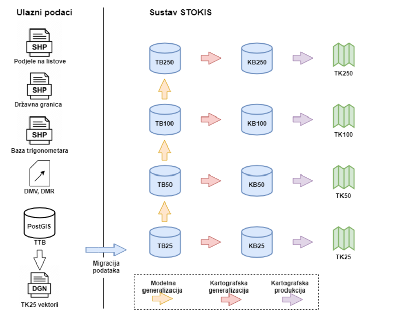
LIST LABS participated in the upgrade of official topographic and cartographic databases and the enhancement of all FME procedures for model and cartographic generalizations for scales: 1:25,000, 1:50,000, 1:100,000, 1:250,000. The level of automation throughout the entire process is extremely high and depends on the configuration of topographic objects. Automation is not only a matter of technical advancement but also a necessity that enables a shortened map production process and reduced costs. The human factor will continue to be required for resolving specific cases of cartographic processing. Cooperation was established with the companies Geomodeling d.o.o. and Zavod za fotogrametriju d.d., and as a result of the project, topographic maps at scales 1:25,000, 1:50,000, 1:100,000, and 1:250,000 were produced for the area covered by one TK250 Vis map sheet.